Showing posts with label Utah. Show all posts

9/6/18

Cable Canyon Trip Report


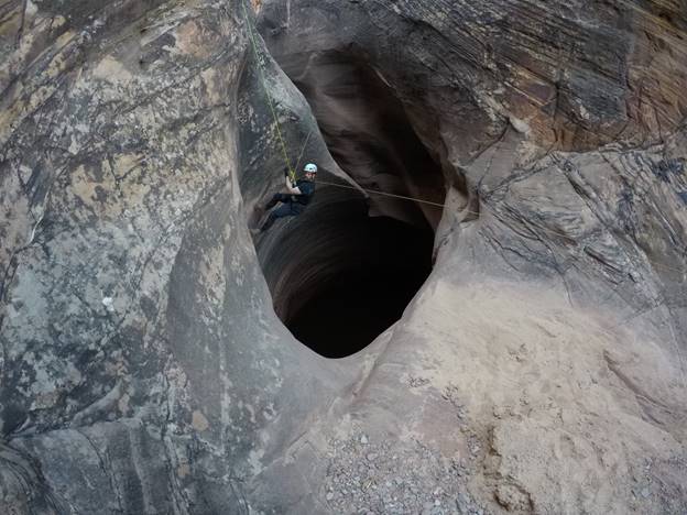
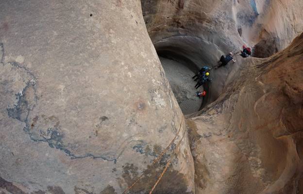
Liberty Mountain Customer Service manager Paul Larkin took a trip through Cable Canyon in the San Rafael Swell of South Eastern Utah. He made the trip with former Liberty Mountain employee Christian Weaver and Paula Weaver. Here are a few of his photos, some helpful stats for anyone interested in attempting the canyon, and a list of the gear that was needed to make it through.


  • The weather was a pleasant high of 85 degrees
  • The trip took 9 hours car-to-car. We started at 7am, dropped into the canyon at 10am, and were back to the cars around 4pm
  • There was a bit of non-technical scrambling on the way into the canyon


  • The canyon required 10 or so rappels, with the longest being about 70 feet
  • There was also quite a bit of down climbing, some stemming and a whole lot of fun
  • At one point we saw a ringtail fox carcass in one of the potholes
  • There was almost no water in the canyon. Often you don't know what water levels will be like going into remote canyons like these, so it's best to be prepared for everything.


  • The only water hole we couldn’t avoid was the first pothole, but the water was only up to our waists
  • We used a variety of canyoneering techniques to make it through including a human ladder using our knees, hands and shoulders to get out of potholes
  • Possibly the best technique of the day was my beached whale anchor over a hump, allowing me to pull up Christian

Share this article with a friend:

10/17/17

Riding the White Rim in a Day


A couple months ago I mentioned to Brayden, one of our Graphic Designers, that I was thinking of biking the White Rim in Canyonlands National Park. I figured that doing it in two days was probably the most realistic option, but quickly saw that most of the campsites along the trail were booked out months in advance. Brayden optimistically said “why don’t you just ride it in a day” and was soon committed to attempting the feat with me. 


Opting for more mental training (aka laziness) than physical in the weeks leading up to the ride, I told myself that I’d be able to push through it and finish the loop. A little more time on the bike would have definitely been helpful. The White Rim is a 100 mile loop that goes around the Island in the Sky portion of Canyonlands. It is almost all double track dirt road except for a few miles of paved highway riding that must be traveled in order to complete the loop. There really aren’t many technical aspects to the ride (unless you’re not comfortable riding through sand, in which case you’re in for a treat) and more than anything it’s a test of endurance. 

Our 6:00am start provided the full sunrise experience 

Looking down the Shafer Switchbacks

After reading a few blog posts and speaking with friends who have ridden the trail, we decided to start riding from the top of Mineral Bottom. This way we would start with a gradual 10ish mile climb to keep warm before the sun came up and then not have any more “major” climbs until the final two miles of the day. We started riding at 6:00 am and were on pace for our 10 hour goal and feeling pretty good for about the first 75 miles. 


The trail winds through some incredible desert scenery with formations different from those seen anywhere else in the area. We debated whether the ride should be done on a gravel bike, but were definitely happy to have some suspension after miles and miles of rocky, bumpy riding. Also, we don’t have gravel bikes. We did see one guy on a wide tire gravel bike, probably a quicker option if your body can handle the beating.

Maybe why it's called the White Rim? Also, Corn Nuts!

While the White Rim is a popular tourist destination, only a limited number of permits are given out each day for both overnight and day use riders. This gives a feeling of remoteness although you will almost certainly pass (or be passed by) other riders and their support vehicles. Even so, it’s best to be prepared with plenty of food, water, and tools/parts for any necessary repairs. Luckily we planned our food and water almost perfectly and had zero bike issues other than a clunky, sandy chain by the end of the ride. I took about 6 liters of water, 3 in a camelback reservoir in my backpack, 2.5 in a handlebar pack, and a water bottle on my bike frame that I filled with Gatorade powder. Foodwise I went with delicious, high calorie options, i.e. Honey Stinger waffles, Probar Bolt chews, Duke’s meat sticks, Corn Nuts, Pop-Tarts, nut butters, etc. Next time I would definitely bring something a bit more “mealy” as it’d be nice to load up on calories 50 or 60 miles in. I would also highly recommend some sort of frame, handlebar, or seat pack so as not to ride with a fully loaded backpack. 


Around mile 80 the trail rides alongside the Green River, creating an explosion of (you guessed it) green erupting from the otherwise red and rocky landscapes experienced for the majority of the ride. At this point we were starting to get pretty tired and a big climb at 90ish miles didn’t help much. After the climb, the trail drops back down and rides alongside the river for another 5-6 miles. Starting above the mineral bottom switchbacks provides the “opportunity” to finish the ride with a grueling climb from river level up to the top of the canyon in just a couple miles. By that point we were worn out to say the least and inched our way up the final climb, eagerly anticipating a big dinner and the chance to sit and relax during the 3 1/2 hour drive home. Total car to car time was about 11 1/2 hours. Longer than we had hoped, but not terrible considering our lack of time spent on a bike this summer.


Overall it was an awesome experience. We had perfect weather, enjoyed incredible scenery, and ate at Arby’s on the way home. Arby’s is really pretty good. I’m fairly certain that both Brayden and I will be back for another go at the loop soon, hopefully much faster now that we have the beta worked out and understand that you should be in decently good shape for this one.


Tyler Jones is a mediocre climber, terrible runner, self proclaimed campfire cook, advocate of playing outside, and Communications Specialist (whatever that means) at Liberty Mountain.


____________

Share this article with a friend:

10/16/17

THE CANYON - Poe Canyon Trip Report


Liberty Mountain business analyst, Christian Weaver, shares a trip report from his recent "stroll" through Poe Canyon in Southern Utah.

The canyon has been in the works for 4-5 years and is what I would consider to be a bucket list canyon. The canyon is often described as one of the more technical canyons in the Colorado Plateau and any descriptions that you can find of the canyon often come with a page full of cautions and warnings.

Last year in the late spring my buddies and I attempted the canyon but failed to even reach it. Accessing the canyon requires a 6-mile cross desert approach to a nearby creek where a basecamp can be established. From the basecamp it's another 2-hour approach to the entry point of the canyon.  Unfortunately, that week of the attempt we had an early heat wave with temperatures approaching triple digits coupled with a delayed mid-afternoon start due to a highway traffic jam causing a few members of the team to suffer heat exhaustion on the initial approach. Ultimately the decision was made to not do the canyon and to seek shade from the heat during the second day and retreat back to our cars in the cool of the evening. To make things even more interesting, my buddy gave birth to a lovely kidney stone on the hike out, making us grateful that we wisely chose to not attempt the canyon.

This year we decided to change up the calendar and attempt the canyon in the fall. Hoping for cooler temps, we chose the second weekend of October. This time we were blessed with perfect weather and no traffic. We started the approach late in the morning and got to the basecamp by late afternoon, half the time it took us the previous year.


A look at the sandstone slopes in which the slot canyon resides
Entering the main creek on the initial approach to the basecamp.
The next morning, we woke up at 5am and started the 2-hour approach to the entry point of the canyon. We hoped to enter the canyon right at sunrise so as to maximize our daylight. Even though the canyon is only a mile long we knew it would take us most of the day to get through. We made the first rappel into the canyon at 7am and immediately began to navigate through the labyrinth of obstacles.


Alpine Start
Massive features of the canyon
One of the major obstacles of the canyon is fact that there are not many bolts in the canyon, and placing new bolts is prohibited due to its geographic location. Without fixed anchors you have to get creative with what you rappel off of. For this canyon we utilized a special anchor called a sand trap (a releasable anchor that is filled with sand from the canyon itself). The procedure for using the sand trap is to send the heaviest team members first with a backup tied to another individual. As you observe the heavier canyoneers descend the rappel you can make the determination of whether or not there is enough sand in the anchor. If the anchor moves then you need to add more sand, if it does not move than you probably have enough sand in the anchor for the last (and lightest) person to rappel off of without the anchor being backed up. Once everyone is down the release cord is pulled which dumps the sand out of the trap and allows the anchor to pull over the edge of the cliff.


Matt starts his rappel with the sand trap in place
The anchor starts moving while Mike is on rappel and everyone jumps on the backup (Brady) to prevent the anchor and him from going over the edge. We need more sand…
Brady rappels off of a sand trap in to the arch room
The water level determines the difficulty of the canyon. When the water is high you swim over many obstacles without any issues. When the water is low, keeper potholes (potholes that can be difficult to climb out of without proper equipment and know how) emerge, upping the difficulty of the canyon. When we descend the canyon there was very little to no water in the canyon itself putting it in what we call “Full-Keeper-Mode.”

The canyon is known for its massive keeper potholes, the largest of these potholes is about 40 feet deep and 20 feet wide. This gigantic pothole has been known to take some teams most of a day to escape and has caused a few overnight bivies. We started off by throwing potshots (small canvas bags filled with sand from the canyon) across the pothole trying to wedge them back behind the lip of a “V” shaped slot 40+ feet away. If a potshot did not land in the right position we would have to pull the potshot back and try again. Sometimes it would take 8-10 attempts to get one potshot positioned just where we thought it needed to be in order to hold a climber. Just the process of throwing the potshots ate up an hour and a half of precious daylight. Once the potshots were in place, I rappelled into the pothole and attempted to climb out using the bundled-up strands of 6mm cord attached to the potshots. Unfortunately, not all the potshots had landed in the correct position and they failed to support my weight as I climbed, forcing me to retreat and ascend back up the rappel line that I had descended.

A look at the big keeper pothole
Video of the big keeper pothole:

I spent almost 25 minutes treading water in the ice-cold pothole. The cold water had gotten to me and I had no desire to re-enter the pot to try again. Plan B was to attempt to bypass the pothole by hooking aid style through a series of small removable bolt holes that have been drilled 30 feet above the bottom of the canyon and then using a stick clip to reach a set of bolts from which you could then pendulum swing to the other side of the pothole from. 3 hours later we finally had everyone safely across.

Mike being assisted across the pothole
With a 6-man team, progress is slow while waiting for everyone to rappel, so we split up into 2 teams and used two working ropes in the canyon. The first team sets up the rappels, rappels off and then takes the second rope and proceeds to the next rappel. The second team takes down the rope and then passes on that rope to the first team so they can continue to progress down the canyon. 

Matt using the cord from a thrown potshot to climb out of another keeper pothole
All together, we ended up spending 10-hours in the canyon, exiting right as the sun started to set. 13-hours from basecamp to basecamp. The canyon was the full experience and had a little bit of everything. Definitely worthy as a line item on my bucket list.

Mike working his way out of a keeper pothole
Phil on rappel to by-pass the below keeper pot.
Once we got back to our basecamp, we filtered some fresh water and hiked the long slog back to the car, arriving at the parking spot around 2:30am.


Final rappel out of the canyon just as the sun starts to set. 

Gear Used


CANYON ROPE 9.1MM X 200' ED  Tough, durable and the Everdry coating makes a huge difference in weight you have to carry once it get wet.
KONG OKA MULTI DESCENDER With the ability to add friction on the fly when rappelling on skinny cords, this is my go-to descender.
3/2MM WETSUIT MENS BLU/BLK MD  and 160258 2MM SHORTY MENS BLU/BLK MD I wore 2 wetsuits to stay warm as the canyon does not see daylight.
SEIRUS NEOSOCK M 6-8.5 This sock keeps your feet warm and prevents blisters in sandy environments.
TECNU SKIN CLEANSER SINGLES We ran into poison ivy at the bottom of the canyon and needed these to keep us from getting a rash.  Life saver!
FIVE TEN GUIDE TENNIE My preferred canyon shoe.  Lightweight and supportive for hiking but handles well on wet rock.  No blisters, no lost toe nails.
BEAL HYDRO BAG Used this bag for the first time and I loved it.  The PVC material did not get heavy when it got wet and was surprising comfortable for the approach into the canyon.
GRAVITYWORKS 4L FILTER SYSTEM My buddy brought this for the trip and I am sold.  It filtered water quick and with little hassle.  I will no longer pump my water.
LM EMERGENCY BLANKET A great emergency blanket for cold, wet canyons.
____________

Share this article with a friend:

4/1/13

Backpacking in Coyote Gulch


Liberty Mountain employee, Lara Egbert shares with us her backpacking trip through Coyote Gulch.

I recently enjoyed a weekend in Coyote Gulch with my boyfriend, his sister, and her husband. Coyote Gulch is in the Glen Canyon National Recreation Area just outside of Escalante, UT and it's a tributary of the Escalante River.


3/22/13

The Benefits of Living In Utah

Q: Why is Liberty Mountain headquartered in Utah's Salt Lake Valley?

A: Because we can still find powder in the middle of March after a short drive to the top of the canyon.


3/13/13

March Mountain Madness


The following adventure report is from Liberty Mountain employee, Marc Maybee.

I went up to Snowbird Resort this past weekend with a couple of buddies, not expecting much as they reported only two inches of fresh snow. We still got up early to try and catch the first or second tram. To our luck, we caught the first tram and decided to head out to Wilber Bowl, one of our favorite runs at Snowbird.

Wilber Bowl is one of the longer sustained runs and for being north facing it usually holds good soft snow. On that day, we had some favorable wind that blew snow from up over the ridge and dumped it into Wilber Bowl. We found spots that were knee and thigh deep and untouched. So much for that two-inch snow report.